Bathymetry of Lake Michigan CD-ROM
On-line Sample
CD-ROM ordering information
   
INTRODUCTION
New bathymetry of Lake Michigan has been compiled as a component of a NOAA
project to rescue Great Lakes lake floor geological
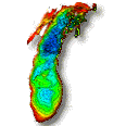
and geophysical data and make it more accessible. This bathymetry was compiled at a scale of 1:250,000,
with a contour interval of 5 meters. This project is a cooperative effort
between investigators at the NOAA National Geophysical Data Center's Marine Geology & Geophysics Division (NGDC/MGG) and the NOAA Great Lakes
Environmental Research Laboratory (GLERL).
A high quality bathymetric chart is of great value as a base map for
geological and limnological sciences as well as for decisionmaking.
Modeling of lake circulation and sediment transport, and predicting the
effects of climate change and toxic waste remediation on the lakeshore are
only a few examples of tasks that can be done better and more accurately
with the availibility of a good base map.
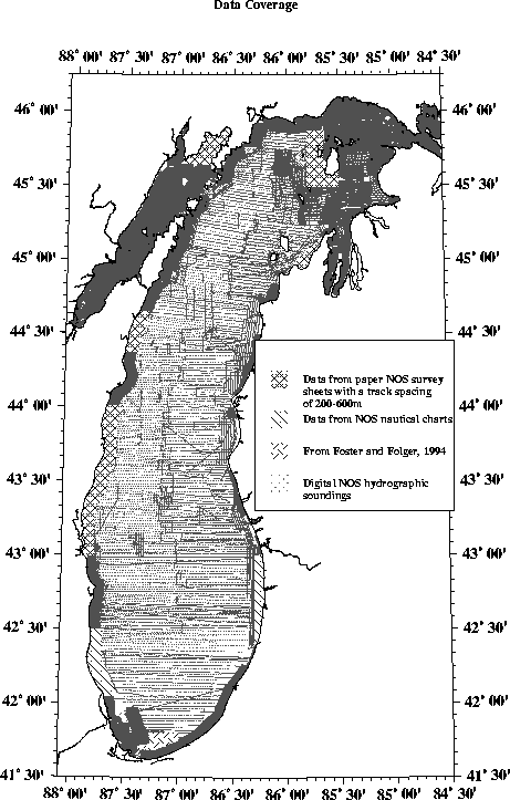
Spacing of data controltracklines is generally about 2000 meters for the
open lake and ranges from 200 to 600 meters for nearshore areas. In
preparation for bathymetric contouring, digital soundings were converted
to metric units and plotted in color according to depth range. From paper sheets, contours in metric units were
generated directly on overlays, these contours were then reduced to the
compilation scale and patched in. Compilation sheets were scanned and
vectorized; and the resulting digital bathymetric contour data constitutes
the primary product. The data were hand contoured by geomorphologists to capture and portray the
maximum information available, a degree of detail not attainable with machine contouring and the density of the data.
Several lake floor feature names mentioned in the text and present on the
images have recently be approved by the U.S. Board on Geographic Names.
Bathymetric data has been collected from the Great Lakes in support of
nautical charting for at least 150 years by the U.S. Army Corp of Engineers
(before 1970), the NOAA National Ocean Service (NOS) (after 1970), and the
Canadian Hydrographic Service. Until now the entire array of more than 600,000
accumulated historic soundings were never used to systematically map the
topography of the floor of Lake Michigan. The digital sounding data used
in this compilation are available from the NGDC Hydrographic Survey Database
System. This system contains area survey data from the National Ocean Service,
the Defense Mapping Agency Hydrographic/Topographic Data Center, and international
sources. The NOS hydrographic data base (NOSHDB), maintained by NGDC in
conjunction with NOS, comprises the majority of NGDC's area survey holdings
and provides extensive survey coverage of the coastal waters and Exclusive
Economic Zone (EEZ) of the United States and its territories.
Lake Michigan Bathymetry Products & Services Available
Maps and color posters at most any scale and projection for all or any
portion of the lake can be generated from the digital data. Custom images
are available, for a charge, upon request. This collaboration has produced
not only this CD-ROM but also a 34"x45" color poster that can be ordered in Data Announcement
96-MGG-03.
For more information:
Great Lakes Data Rescue Page
URL: http://www.ngdc.noaa.gov/mgg/greatlakes/greatlakes.html
Introduction | Geomorphology | Raster data files | Vector data files | Images
|
