![]()
![]()
![]()
![]()
![]()
![]()
![]()
![]()
![]()
![]()
![]()
![]()
![]()
![]()
![]()
Teachers
Guide to Stratovolcanoes of the World
Facts and Figures
Mount
St. Helens, Washington USA:
Facts | Story
| Feature | Questions
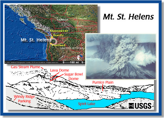
Location: State of Washington, USA
Latitude and Longitude: 46.2º N, 122.2º W,
Elevation: 2,549 m (8,363 ft)
Volcano Type: Stratovolcano
Earliest Eruption: 10,000 BP
Oldest Historic Eruption: 1831
Most Recent Eruption: 2008
Number of Eruptions in 20th Century: 5
Largest Eruption: -1855 BP VEI = 6; 1800 VEI = 5; 1980 VEI = 5, 57 deaths
Notable Feature(s): During the 1980 eruption, the "Bulge" on north face, lateral blast removed the upper 396 m (1,306.8 ft) of the volcano.
Notable Statistic: The May 18, 1980 blast devastated 596 square kilometers (229 square miles) and destroyed timber valued at several million dollars. This was the deadliest and most economically destructive volcanic event in the history of the United States.