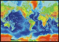
Surface of the Earth Poster, Revised March 2000
World Data Service for Geophysics, Boulder

NGDC (now NCEI) DATA ANNOUNCEMENT NUMBER: 00-MGG-05
MGG-5R: A Full Color Poster measuring 31 by 43 inches
2 minute ETOPO2v2 database
This image was generated from digital data bases of land and sea-floor
elevations on a 2-minute latitude/longitude grid (1 minute of latitude =
1 nautical mile, or 1.853 km). Assumed illumination is from the west;
shading is computed as a function of the east-west slope of the surface
with a nonlinear exaggeration favoring low-relief areas. A Mercator
projection was used for the world image, which spans 390° of longitude
from 270° West around the world eastward to 120° East; latitude coverage
is ±80°. The resolution of the gridded data varies from true 2-minute
for the Atlantic, Pacific, and Indian Ocean floors and all land masses
to 5 minutes for the Arctic Ocean floor.
Major Sources of Data:
- The seafloor data between latitudes 72° North and 72° South are from the work
of Smith and Sandwell (1977). These data were derived from satellite altimetry
observations combined with carefully, quality-assured shipboard echo-sounding measurements,
by Dr. Walter H.F. Smith, of the NOAA Laboratory for Satellite Altimetry and
Dr. David T. Sandwell, of the Institute of Geophysics and Planetary Physics
at the University of California, San Diego.
For reference on the generation of these data, consult:
W.H.F. Smith and D.T. Sandwell, "Global Sea Floor Topography from Satellite
Altimetry and Ship Depth Soundings," Science Magazine, vol. 277, issue 5334, 1997.
More Information
- Seafloor data poleward of 72° are from the US Naval Oceanographic Office's (NAVOCEANO)
Digital Bathymetric Data Base 5-minute (DBDB5).
- Land topography is from the GLOBE Project, an internationally designed, developed,
and independently peer-reviewed global digital elevation model (DEM), at a
latitude-longitude grid spacing of 30 arc-seconds (30"). The GLOBE Task Team was
established by the Committee on Earth Observation Satellites (CEOS). It is part of
Focus I of the International Geosphere-Biosphere Programme - Data and Information System.
Primary contributors to the GLOBE database are:
- National Imagery and Mapping Agency (formerly Defense Mapping Agency), Fairfax, Virginia, USA
- Geographical Survey Institute, Tsukuba, Japan
- Australian Surveying and Land Information Group, Canberra, ACT, Australia
- Jet Propulsion Laboratory, Pasadena, California, USA
- University College London, UK
- DLR-German Remote Sensing Data Center, Oberpfaffenhofen, Germany
- NOAA National Geophysical Data Center (now the National Centers for Environmental Information), Boulder, Colorado, USA
- USGS EROS Data Center, Sioux Falls, South Dakota, USA
More information on the GLOBE project
More information about bathymetry, topography, and relief data and products. We offer posters, images, and digital global relief data on CD-ROM. For close-up online viewing and download of images related to this poster, please check the online 2-minute relief image viewing page.
|

