|
NGDC-720 Crustal Field Model (Discontinued) | |||||||||||||||||||||||||||||||||||||||||||||||||||||||||||||
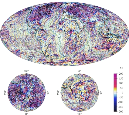
 Earth's Crustal Magnetic Field
(larger image)
 |
The NGDC-720 research model preceded the Enhanced Magnetic Model. The NGDC-720 will not be updated. The archived model and coefficients are provided for software evaluation and testing purposes. The magnetic field at or near the surface of the Earth is a combination of Earth's magnetic field and fields of external (solar) origin. The Earth's magnetic field is itself a superposition of the field generated by the geodynamo in the liquid outer core (main field) and the field of magnetized rocks in the crust and upper mantle. The main field dominates the long wavelengths, down to about 3000 km, whereas the crustal field dominates at wavelengths smaller than 2500 km. A very convenient way of representing geomagnetic fields is to expand the scalar magnetic potential into spherical harmonic functions. Such a model can then be evaluated at any desired location to provide the magnetic field vector, its direction, or the anomaly of the total intensity of the field. The NGDC-720 model provides such an expansion for the crustal field from spherical harmonic degree 16 to 720, corresponding to the waveband of 2500 km to 56 km. The degree 720 cut-off corresponds to an angular wavelength of 30 arc minutes, providing a 15 arc minute model resolution. The NGDC-720 model was compiled from satellite, marine, aeromagnetic and ground magnetic surveys (see our acknowledgement of data providers and collaborators). First, the aeromagnetic and marine magnetic data were combined to a common grid. Since the long wavelength field is more reliably determined by satellite, the wavelengths larger than 330 km were then replaced with a CHAMP satellite crustal field model (see the CIRES Geomagnetic Web site MF6 model). Finally, the coefficients of the magnetic potential were estimated in a standard least squares inversion. |
||||||||||||||||||||||||||||||||||||||||||||||||||||||||||||
Why is this important?Many different applications utilize Earth's magnetic field,whether for navigation, resource evaluation, or research. The magnetic field experienced at or near the Earth's surface is a combination of the main magnetic field, the relatively static crustal magnetic field, and the rapidly time-varying external magnetic field (solar origin). The better we are able to define these fields, the more accurate the results. NGDC, working with the National Geospatial-Intelligence Agency, produces the World Magnetic Magnetic Model - a main field model - and is developing an Enhanced Magnetic Model for improved navigation. The NGDC-720 model is the first step in this process. We are also collaborating with scientists involved in the International Association of Geomagnetism and Aeronomy (IAGA) to develop a World Digital Magnetic Anomaly Map. Acknowledgments
How to Cite These Data:
|
|||||||||||||||||||||||||||||||||||||||||||||||||||||||||||||
NGDC-720 Model - Coefficients, Grids, and Movies
|
|||||||||||||||||||||||||||||||||||||||||||||||||||||||||||||