 Great Lakes Data Rescue
Project - Lake Ontario Bathymetry
Great Lakes Data Rescue
Project - Lake Ontario Bathymetry
Click on a link in the list below to go to text on this page with that heading. Thumbnail image links are found with the appropriate text.
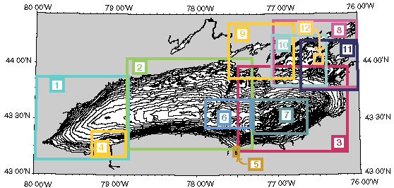
To view the images click on the numbered boxes at right or on the images without text in the list below. The full resolution version of these images found in the images/a#_lg.jpg files can also be printed on 8.5"x11" paper.
|
|

 Around the perimeter of the lakefloor, the high energy of water circulation has evidently prevented the deposition of postglacial muds, except in sheltered areas (Thomas et al., 1972). Strongly linear bathymetric features displaying the imprint of glaciation, or of exhumation of bedrock topography and structure, occur at intervals along almost all of the lakeshore. Study of bottom sediment types off the western lakeshore between Niagara and Oshawa revealed that extensive areas of exposed bedrock, boulder pavement, sand deposits, and glacial drift occur here (Rukavina, 1969; Rukavina, 1976). Apparently in most areas around the lake perimeter, Quaternary sediments are relatively thin or absent, and bedrock exposures are common, possibly reflecting the effects of subglacial erosion and subsequent abrasion by lacustrine waves and currents.
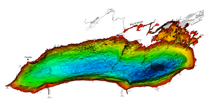
 New bathymetry has revealed the presence of a small basin between the Mississauga and Rochester Basins and we have given it the new name, Genesee Basin. The four axial basins, separated by three ridges, occupying the floor of Lake Ontario are from west to east the Niagara, Mississauga, Genesee, and Rochester Basins. North of the Niagara River mouth and to the west, in the subtly defined Niagara Basin (which barely exhibits topographic closure), the deep axis of the lake is about midway between north and south shores. Farther east, the axial depths of the other three basins lie well toward the southern edge of the lake, giving the lake a distinct asymmetry in its north-south profile. This asymmetry is related to the bedrock configuration underneath the lake floor, and its differential resistance to glacial erosion (Hutchinson, et al., 1993). Gently southward dipping, erosion-susceptible shales and redbeds of the Middle and Upper Ordovician Utica Formation, Lorraine Group (Blue Mountain and Georgian Bay Formations in Ontario), and Queenston Formation, overlie southward-dipping erosion-resistant limestones of the Middle Ordovician Trenton Group (Cobourg and Lindsay Formations in Ontario).
In the deep axis of the Mississauga Basin from 146-182 meters depth, there are several ledges of a few meters relief, separated by scarplets that trend north to south. These features step down from west to east toward the deepest point in the basin. Although the origin of the ledges is not known, they might have formed on the eroded edges of a succession of gently dipping strata which are characterized by bed-to-bed variation in resistance to erosion. Rudimentary valleys and channels of only a few meters relief are superimposed on the ledges and appear to represent a drainage pattern. Formation of the ledges could have been the result of the erosional action of Wisconsin glaciation and/or subglacial meltwater floods, acting against the differential resistance to erosion and layered aspect of the sedimentary strata (probably Trenton Limestone; Sanford and Baer, 1981) underlying the lake floor.
 Seismic sections show that the Scotch Bonnet and Point Petre Ridges are underlain by bedrock highs; at one location the Scotch Bonnet Ridge is bounded on the northwest by a 25 meters escarpment (Anderson and Lewis, 1975; Forsyth, et al., 1994). The Salmon Point Ridge lies between these two ridges, does not extend as far out into the lake, and trends in a NE-SW direction oblique to the other two ridges. Valleys also interpreted as bedrock features extend NE-SW, paralleling the two main ridges and lying between and adjacent to them (Hutchinson, et al., 1993). The Cobourg Valley seems to be an extension of the Bay of Quinte and may stretch out near the 130 meter contour, deeper (and longer) than any of the other valleys. Some of these features are lineated in the same direction as faults and bedrock lineations occurring to the northeast in Ontario in the distinct NE-SW fabric of the Grenville basement rocks (Forsyth, et al, 1994). The Scotch Bonnet Ridge also seems to lie on the northward extension of the Clarendon-Lynden Fault system in New York (Hutchinson, et al., 1979). A channel (Scotch Bonnet Gap) which breaches the Scotch Bonnet Ridge connects the Mississauga and Genesee Basins near the deep axis of the lake. Deep connections also occur between the Niagara and Mississauga Basins and the Genesee and Rochester Basins (Genesee Gap).
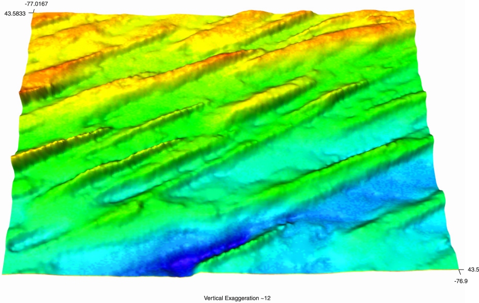
 A series of distinct NE-SW ridges occupy the floor of Lake Ontario's deepest basin, the Rochester Basin. These ridges, having a relief of 15-25 meters and a natural spacing of 250-1000 meters, are remarkable in their linear aspect and uniform width. Most have relatively flat tops with steep side slopes, some of which are steeper to the northwest, others to the southeast, and some are symmetrical in cross-profile. Seismic and sediment core data suggest that many of the ridges coincide with the underlying relief of glacial landforms beneath the lake sediment (Hutchinson, et al., 1993). Resemblance exists between these features and grooved topography occurring in onshore drumlin fields north of the lake, as noted by Lewis (1997). Some of the Rochester Basin ridges are also abruptly truncated on their rounded northeastern ends, opposing the direction of ice advance, a distinct feature observed in drumlin fields. An alternate interpretation has been proposed for the ridges, namely, that the side slopes of the ridges have resulted from faulting (Thomas, et al., 1993). The parallel ridges of the Rochester Basin trace an arc from NE-SW to nearly east-west, which suggests they were formed by subglacial flow following the changing trend of the southern side of the basin, as if flow was deflected westward by the massive bulk of the Allegheny Plateau to the south. The relative roles of ice and meltwater floods in forming these ridges is a topic of continuing research.


 At the southern rim of the East Kingston, Galloo, and Stony Basins there occurs a series of broad low ridges which individually trend NE-SW, but which coalesce to form a complex ridge extending from the west near Prince Edward Point, Ontario to the east near Stony Point, New York. This feature has a relief ranging from 20-30 meters and is asymmetrical, with steep northeast facing scarps, and gently sloping surfaces facing southwest toward the main basin of Lake Ontario. The cuesta features seen here are gently rounded to flat on top, and several are capped by islands, the principal of which are Main Duck, Galloo, and Stony Islands. The Simcoe Island, Saint Lawrence, and Black River Channels are incised through the Duck-Galloo Ridge and extend NE-SW across the above mentioned basins. All three channels broaden out at the southern margin of the Duck-Galloo Ridge. This was probably the location of the Lake Ontario shoreline in early postglacial time, and the three channels were probably the main outflow channels for the lake at this time (Anderson and Lewis, 1985).
Several small shallow basins with intervening ridges occur in the northeastern extremity of Lake Ontario, all having depths of generally less than 40 meters. The bathymetry exhibits a preferred orientation of NE-SW, and appears to be largely a water-covered extension of the topography occurring northeast of the lake. The basins were probably produced by glaciation followed by some sedimentary infilling and topographic smoothing. Bedrock, consisting of Ordovician limestones and shales, caps the ridges and shoals separating the basins at or near the lake floor surface (Sly and Prior, 1984).
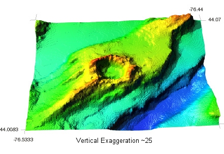
 A small equidimensional circular depression 1000 meters in diameter, with a continuous encircling rim, coincides with the feature referred to as Charity Shoal on nautical charts. An elongated ridge extends southwest from the feature, resembling the tail of a crag-and-tail feature common to some drumlin fields. The basin is slightly deeper than 18 meters and the rim rises to depths of 2-6 meters. The origin of the feature remains unknown. Although a sinkhole in the limestone terrane is a possibility, an origin related to a meteor crater, that was subsequently glaciated, seems more likely. Aeromagnetic mapping by the Geological Survey of Canada revealed a negative magnetic anomaly over Charity Shoal, which is a characteristic feature of simple impact craters (Pilkington and Grieve, 1992).
Anderson, T. W., and C. F. M. Lewis, 1975, Acoustic Profiling and Sediment Coring in Lake Ontario, Lake Erie, and Georgian Bay, in GEOLOGICAL SURVEY OF CANADA REPORT OF ACTIVITIES: part A, paper 75-1, p. 373-376. Return to text.
Anderson, T.W., and C. F. M. Lewis, 1985, Postglacial Water Level History of the Lake Ontario Basin, in Karrow, P. F. and P. E. Calkin (eds.), QUATERNARY EVOLUTION OF THE GREAT LAKES, Geological Association of Canada Special Paper 30, p. 231-253. Return to text.
Bloom, A. L., 1991, GEOMORPHOLOGY: A SYSTEMATIC ANALYSIS OF LATE CENOZOIC LANDFORMS, Englewood Cliffs NJ, Prentice Hall, 532p.
Chapman, L. J., and D. F. Putnam, 1951, THE PHYSIOGRAPHY OF SOUTHERN ONTARIO, University of Toronto Press, 284p., maps.
Clark, J. A., M. Hendriks, T. J. Timmermans, C. Struck, and K. J. Hilverda, 1994, Glacial Isostatic Deformation of the Great Lakes Region, GEOLOGICAL SOCIETY OF AMERICA BULLETIN, v. 106, p. 19-31.
Delorme, L. D., R. L. Thomas, and P. F. Karrow, 1990, Quaternary Geology, Waterloo/ Burlington and Lake Ontario, in McKenzie, D. I. (ed.), QUATERNARY ENVIRONS OF LAKES ERIE AND ONTARIO, A FIELD GUIDE PREPARED FOR THE FIRST JOINT MEETING OF THE CANADIAN QUATERNARY ASSOCIATION AND THE AMERICAN QUATERNARY ASSOCIATION, WATERLOO, ONTARIO, CANADA, p. 142-162.
Forsyth, D. A., B. Milkereit, C. A. Zelt, D. J. White, R. M. Easton, and D. R. Hutchinson, 1994, Deep Structure Beneath Lake Ontario: Crustal Scale Grenville Subdivisions, CANADIAN JOURNAL OF EARTH SCIENCES, v.31, p. 255-270. Return to text.
Hutchinson, D. R., P. W. Pomeroy, R. J. Wold, and H. C. Halls, 1979, A Geophysical Investigation Concerning the Continuation of the Clarendon-Linden Fault Across Lake Ontario, GEOLOGY, v. 7, p. 206-210. Return to text.
Hutchinson, D. R., C. F. M. Lewis, and G. E. Hund, 1993, Regional Stratigraphic Framework of Surficial Sediments and Bedrock Beneath Lake Ontario, GEOGRAPHIE PHYSIQUE ET QUATERNAIRE, v. 47, no. 3, p. 337-352. Return to "Lake Basin..." text. Return to "...Central Northshore" text. Return to "...Rochester Basin" text.
Kemp, A. L. W., T. W. Anderson, R. L. Thomas, and A. Mudrochova, 1974, Sedimentation Rates and Recent Sedimentary History of Lakes Ontario, Erie, and Huron, JOURNAL OF SEDIMENTARY PETROLOGY, v. 44, no. 1, p. 207-218.
Kemp, A. L. W., and N. S. Harper, 1976, Sedimentation Rates and a Sediment Budget for Lake Ontario, JOURNAL OF GREAT LAKES RESEARCH, v. 2, no. 2, p. 324-340.
Lewis, C. F. M., and P. G. Sly, 1971, Seismic Profiling and Geology of the Toronto Waterfront Area of Lake Ontario, PROCEEDINGS OF THE 14TH CONFERENCE ON GREAT LAKES RESEARCH, International Association of Great Lakes Research, p. 303-354.
Lewis, C. F. M., L. A. Mayer, G. D. Cameron, and B. J. Todd, 1997, Drumlins in Lake Ontario, in T. Davies, et al., (eds.), GLACIATED CONTINENTAL MARGINS: AN ATLAS OF ACOUSTIC IMAGES, Chapman and Hall, London, p. 48-49. Return to text.
Martini, I. P., and J. R. Bowlby, 1991, Geology of the Lake Ontario Basin: A Review and Outlook, CANADIAN JOURNAL OF FISHERIES AND AQUATIC SCIENCES, v. 48, p. 1503-1516.
Muller, E. H., and D. L. Pair, 1992, Comment and Reply on: "Evidence for Large-Scale Subglacial Meltwater Flood Events in Southern Ontario and Northern New York State," GEOLOGY, v. 20, p. 90-91.
Pilkington, M., and R. A. F. Grieve, 1992, The Geophysical Signature of Terrestrial Impact Craters, REVIEWS OF GEOPHYSICS, v. 30, no. 2, p. 161-181. Return to text.
Rukavina, N. A., 1969, Nearshore Sediment Survey of Western Lake Ontario, Methods and Preliminary Results, PROCEEDINGS OF THE 12TH CONFERENCE ON GREAT LAKES RESEARCH, International Association of Great Lakes Research, p. 317-324. Return to text.
Rukavina, N. A., 1976, Nearshore Sediments of Lakes Ontario and Erie, GEOSCIENCE CANADA, v. 3, no. 3, p.185-190. Return to text.
Sanford, B. V., and A. J. Baer, 1981, Geological Map of Southern Ontario, GEOLOGICAL ATLAS 1:1,000,000 (R. J. W. Douglas, coordinator), Geological Survey of Canada, map 1335A, sheet 30S. Return to text.
Shaw, J., and R. Gilbert, 1990, Evidence for Large-Scale Subglacial Meltwater Flood Events in Southern Ontario and Northern New York State, GEOLOGY, v. 18, p.1169-1172.
Sly, P. G., and J. W. Prior, 1984, Late Glacial and Postglacial Geology in the Lake Ontario Basin, CANADIAN JOURNAL OF EARTH SCIENCES, v. 21, p. 802-821. Return to text.
Sly, P. G., 1984, Sedimentology and Geochemistry of Modern Sediments in the Kingston Basin of Lake Ontario, JOURNAL OF GREAT LAKES RESEARCH, v. 10, no. 4, p. 358-374.
Teller, J. T., 1987, Proglacial Lakes and the Southern Margin of the Laurentide Ice Sheet, in W. F. Ruddiman and H. E. Wright Jr., eds., NORTH AMERICA AND ADJACENT OCEANS DURING THE LAST DEGLACIATION, Decade of North American Geology, Geological Society of America, v. K-3, p. 39-70.
Thomas, R. L., A. L. W. Kemp, and C. F. M. Lewis, 1972, Distribution, Composition, and Characteristics of the Surficial Sediments of Lake Ontario, JOURNAL OF SEDIMENTARY PETROLOGY, v. 42, p. 66-84. Return to text.
Thomas, R. L., J. L. Wallach, R. K. McMillan, J. R. Bowlby, S. K. Frape, D. L. Keyes, and A. A. Mohjaer, 1993, Recent Deformation in the Bottom Sediments of Western and Southeastern Lake Ontario and its Association with Major Structures and Seismicity, GEOGRAPHIE PHYSIQUE ET QUATERNAIRE, v. 47, p. 325-335. Return to text.