Versions Available
- 10 sheet set
(each 74 x 90 cm)
1:1,000,000 scale
at 38 deg. N
- Photo-reduction to
1:5,000,000 scale
- downloadable images
|
click on map above for a larger preview
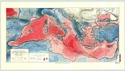
This Bouguer gravity anomaly map was compiled by Jannis Makris of the Institut fur Geophysik in Hamburg, and Carlo Morelli of the Istituto di Miniere e Geofisica Applicata in Triesete. It is published by the Charts Division of the Head Department of Navigation and Oceanography in Russia under the authority of the Intergovernmental Oceanographic Commission (IOC) of UNESCO. The primary data are from over 114,000 nm of marine survey carried out in 1965-1972 by OGS in Trieste, and in 1973-1974 by the Dept. of Geodesy and Geophysics of Cambridge University, together with land compilations. It presents the anomalies in milligals, based upon the 1967 normal gravity formula, a 2.67 g/cm3 Bouguer density, and topographic corrections to 167 km for the land area in the easternmost four sheets. Contours are every 10 mGal with changes in tint every 50 mGal. Red tints are positive. The bathymetry is from the 200 m contours of the original IBCM with supplemental 20 m, 50 m, and 100 m contours at sea. Two versions are available; a 10 sheet set (each 74 X 90 cm) at 1:1,000,000 scale at 38 degrees N, and a photo-reduction to 1:5,000,000 scale.
|

 Return to IBCM Home Page