, formerly the NOAA National Geophysical Data Center (NGDC)")
|

|
Core Data from the Deep Sea Drilling Project
DSDP holes in the Bering Sea
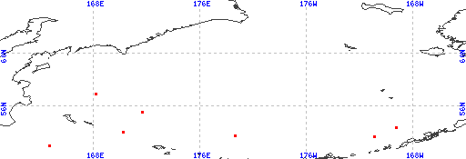
Red dots represent sites. Overprinted locations include links to adjacent sites.
hole leg latitude longitude 184 19 53.7107 -170.9232 184A 19 53.7107 -170.9232 184B 19 53.7107 -170.9232 188 19 53.7535 178.6593 189 19 54.0357 170.2230 185 19 54.4288 -169.2432 190 19 55.5592 171.6403 191 19 56.9450 168.1787 191A 19 56.9450 168.1787 191B 19 56.9450 168.1787 |
|
Cite as: Deep Sea Drilling Project (1989): Archive of Core and Site/Hole Data and Photographs from the Deep Sea Drilling Project (DSDP). National Geophysical Data Center, NOAA. doi:10.7289/V54M92G2 [access date]
Please see NOAA's privacy and disclaimer information. Send questions or comments to mgg.info@noaa.gov.
|