AGE OF THE OCEAN FLOOR POSTER
World Data Service for Geophysics, Boulder
Click image for enlarged view (337 KB JPG file)
Or here for a really enlarged view (1.6 MG GIF file)
A 2008 Age Grid is available
DATA ANNOUNCEMENT NUMBER: 96-MGG-04
Report MGG-12
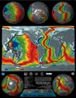
A 24"x31" Poster in Full Color
The images used to create the poster are a composite of topographic and bathymetric data available from NGDC (now NCEI) and crustal age data generated through a cooperative project between the institutions below:
- R. D. Mueller,
Department of Geology and Geophysics, Building F05, University of Sydney, N.S.W. 2006, Australia
- W. R. Roest, Geological Survey of Canada, 1 Observatory Crescent, Ottawa ON, K1A 0Y3, Canada
- J.-Y. Royer, Lab. de Geodynamique, O.O.V., La Darse, B.P. 48, 06230 Villefranche Sur Mer, France
- L. M. Gahagan, Institute for Geophysics, University of Texas, 8701 Mopac Boulevard, Austin, TX 78759-8345
- J. G. Sclater, Scripps Institution of Oceanography, UCSD, 9500 Gilman Drive, La Jolla, CA 92093-0215
A published reference for the age grid is: Mueller, R.D., Roest, W.R.,
Royer, J.-Y., Gahagan, L.M., and Sclater, J.G., A digital age map of the
ocean floor. SIO Reference Series 93-30, Scripps Institution of Oceanography.
The color image representing crustal ages was created from a digital age grid of the ocean floor with a grid node interval of 0.1 degrees using a self-consistent set of global isochrons and associated plate reconstruction poles by the authors listed above. The age at each grid node was determined by linear interpolation between adjacent isochrons in the direction of spreading. Ages for ocean floor between the oldest identified magnetic anomalies and continental crust were interpolated by estimating the ages of passive continental margin segments from geological data and published plate models. The quality of the grid is subject to variations depending on data coverage.
The crustal age coloration was then applied to relief images derived from NGDC (now NCEI) topographic data. Light gray areas are sediment-covered continental shelf materials; the darker gray color indicates land. The age-color overlay image is by R. Dietmar Mueller, University of Sydney; combined age-relief images by Peter W. Sloss, NOAA-NESDIS-NGDC (now NCEI).
|

