|
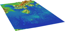
Southern Alaska Coastal Relief Model image of So Alaska CRM")
The Southern Alaska Coastal Relief Model is a 24 arc-second digital elevation model ranging from 170° to 230° and 48.5° to 66.5° N. It integrates bathymetry and topography to represent Earth's surface and spans over the Gulf of Alaska, Bering Sea, Aleutian Islands, and Alaska's largest communities: Anchorage, Fairbanks, and Juneau. The relief model was built from a variety of source datasets acquired from the National Centers for Environmental Information (NCEI), National Ocean Service, United States Geological Survey, National Aeronautics and Space Administration, and other U.S. and international agencies.
The CRM provides a framework to enable scientists to model tsunami propagation and ocean circulation. In addition, it may be useful for benthic habitat research, weather forecasting, and environmental stewardship. Color Image of the Southern Alaska CRM
A color shaded-relief image of the Southern Alaska CRM, created by NCEI, is displayed above. The image is downloadable as a georeferenced TIFF. The image was created with Generic Mapping Tools (GMT) and Persistence of Vision Raytracer (POV-Ray).
Download the Southern Alaska CRM
*ArcGIS users - use binary float and convert using 'Float to Raster'
How to Cite the Southern Alaska CRM:
Lim, E., B.W. Eakins, and R. Wigley, Coastal Relief Model of Southern Alaska: Procedures, Data Sources and Analysis, NOAA Technical Memorandum NESDIS NGDC-43, 22 pp., August 2011.
|
|
 |
|
| All Bathy/Relief | Coastal DEMs | Fishing | Global | Lakes | Multibeam | NOS |