Report: Arctic Bathymetry Workshop
September 18-19, 1997 St. Petersburg, Russia
DEVELOPMENT OF A MODERN BATHYMETRIC DATA BASE FOR THE ARCTIC
An earlier version of this document was widely circulated in early 1997 by the Interim Steering Committee for the proposed IASC Working Group for Arctic Bathymetry
Objective
The goal of this initiative is to develop a digital data base that contains all available bathymetric data north of 64 degrees N, for use by mapmakers, researchers, and others whose work requires a detailed and accurate knowledge of the depth and the shape of the Arctic seabed.
Background
Ample anecdotal evidence exists concerning the inadequacy of published charts of the Arctic Ocean. Numerous field investigators have reported significant differences between observed and charted depths, which have resulted in planning and operational difficulties.
The lack of accurate bathymetry in the Arctic is no less a disadvantage for shore-bound investigators who require reliable, detailed information. Oceanographers need to know more about underwater relief to improve their models of Arctic Ocean circulation. These studies advance our understanding of the global weather machine and help predict the transport of contami- nants. Detailed bathymetry is essential for environmentalists who study the sometimes destructive interactions between Man and the sea floor, e.g. the dispersion of toxic wastes, or the impact of moving ice on seabed installations. Geoscientists need detailed information for a wide range of investigations that range from the present distribution of bottom sediments, to the tectonic history of oceanic regions. Marine boundary specialists need precise locations of key features on the sea bed for the preparation and evaluation of national claims for jurisdiction over seabed resources beyond 200 nautical miles, according to the provisions of Article 76 of the Law of the Sea.
There are several reasons why the floor of the Arctic Ocean is so poorly known: the permanent ice cover has made it difficult and costly to collect soundings; climate and remoteness have posed formidable logistical problems; and perhaps most significantly, the region has until recently served as a theatre for superpower politics. Improved technology coupled with significant political developments are changing this picture, raising the possibility of dramatic improvements to the description of the Arctic seabed.
A preliminary inventory of available data sets
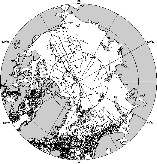
Unlike some other oceanic regions, public-domain bathymetry is sparse in the Arctic Ocean. Sheet 5.17 of the General Bathymetric Chart of the Ocean (GEBCO; Canadian Hydrographic Service, 1979) is widely used to portray the sea floor north of 64 degrees N. (This is a standard paper chart, however a digital version is now available in hardcopy and computer-readable form, as seen on the Cover). Sheet 5.17 was developed in 1979 from the very limited data set shown in Figure 1, which illustrates sounding track lines extracted from the GEBCO Digital Atlas (Jones et al, 1994). Observations along these tracks were used to develop manually-drawn contours portrayed north of 64 degrees N in the GEBCO sheets (although not all track lines shown between 64 degrees N and 72 degreesN in the Norwegian-Greenland and Barents Seas were used in the construction of Sheet 5.17). The data used in this chart was collected in analog form, with poor navigation. We believe however that this data adequately documents the approximate positions and orientations of the major bathymetric features in the basin.
Since the late 70's, a number of cruises have operated in the Arctic Ocean. The data collected during these efforts, combined with data anticipated over the next few years from improved observations, makes 1997 an ideal time to develop a new Arctic data base.
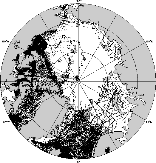
Figure 2 illustrates public-domain bathymetry that is available in digital form from data centres in Canada and the USA. The density of these data sets is inhomogeneous and totally inadequate for an accurate portrayal of the sea floor in the main part of the Arctic Ocean. Other data sets exist. Negotiations for the release of new or uncirculated information will help paint a more accurate picture. The Russian Navy is known to have accumulated numerous soundings throughout the Arctic Ocean, which are currently being used to develop a 1:5 million contour map; there are indications that these soundings may also be converted eventually to grid form. Investigations are underway to determine if the US Navy holds a similar data set, and if so, what is the likelihood of its release for this project.
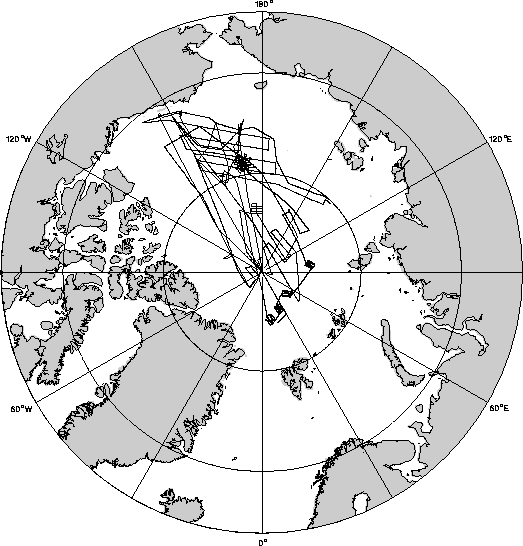
Perhaps the most promising development in Arctic bathymetry is the US Navy's SCICEX program, which commits specific submarine missions to unclassified mapping and research beneath the permanent polar pack. The general policy is to release data into the public domain no later than two years after the cruise completion date. So far, cruises in 1993, 1995, and 1996 have collected single-beam soundings in key areas selected on the basis of scientific priorities (Figure 3); in 1998, the program is expected to include a swath mapping capability. SCICEX represents a significant advance in Arctic bathymetry supported by relatively modern positioning systems; every effort will be made to incorporate this new information into the proposed data base, as it will no doubt figure heavily in the consolidation and adjustment of other observations.
Expected participation and means of support
All organizations that hold or use Arctic bathymetric data are encouraged to participate, e.g. members of the International Hydrographic Organization, naval and hydrographic services, data centres, national research laboratories, universities, etc. The basic criteria for involvement in the project are: (a) a strong interest in developing an improved description of the sea floor in the Arctic; and (b) a willingness to contribute actively to the attainment of that objective through funding, data contributions, or the provision of scientific and technical expertise. Preliminary discussions with potential participants have revealed a high level of enthusiasm for the objectives of this initiative, as well as a readiness to take part in a constructive fashion. In this context, an early version of this proposal has been presented to Member States of the International Hydrographic Organization, and has met with favourable response.
Details concerning project staffing and management will be resolved through early discussion among committed participants. In establishing the core group of workers and the terms of reference for this initiative, due care will be exercised to ensure that all project activities and policies are well coordinated with those of other undertakings that have related objectives.
No individual source of funding has been identified to underwrite the entire cost of the initiative. Support for the project will most likely consist of cash and in-kind contributions from participating organizations and from interested sponsors. For example, IASC has agreed in principle to partially sponsor an initial participants' Workshop (Item 1 in the following section). In-kind contributions (staff salaries, use of technical facilities, etc) will be sought from participating agencies as appropriate. Nominal fees may be charged to defray the cost of distributing final products to the end users, but that proposition is subject to further discussion.
Proposed implementation: major tasks and preliminary time table
- Organize Workshop to review candidate data sets and to develop work plan (September 1997);
- Assemble all available sets of bathymetric observations (September 1997 to August 1998);
- Merge the observations into a digital data base (January 1998 to December 1998);
- Use the new data base to produce improved maps (December 1998 to June 1999);
- Place the data base, maps, and documentation into public circulation (September 1999);
- Recommend priorities for future mapping and research (September 1999).
Reporting and data management
The project operators will implement a reporting mechanism to ensure that participants, sponsoring organizations, and other interested parties are kept aware of progress through the regular circulation of newsletters and/or postings on the Internet. Also, participants will be encouraged to report developments through presentations at international meetings and/or publications in the appropriate journals. All data sets used in the final products, as well as the procedures followed in their handling and processing, will be fully documented.
Particular attention will be directed to data management issues, as the intent is to create a live' data base that can be expanded and upgraded whenever new sets of observations become available. Data will be preserved in both raw and corrected form, in case it should prove necessary at some future date to re-process original observations.
Data release and distribution
The main objective of the compilation is to develop a coherent data base that incorporates all available bathymetric observations, which will be used to construct a regular grid of depth values. This grid will be placed in the public domain for free and unrestricted use by anyone. If past experience is any guide, many of the original observations will already be in the public domain, so relatively few problems are expected in releasing them along with the gridded values; other original data sets may be proprietary and hence may remain unavailable for open circulation in the near future.
The grid will also be circulated in map form, most notably a 1:6 million Polar Stereographic map of the Arctic region north of 64 degrees N.
The Interim Steering Committee
At the time this proposal was originally circulated, the Interim Steering Committee consisted of four volunteers:
- Norman Cherkis, US Naval Research Laboratory, Washington DC, USA Tel: (202)402-1103; E-mail: fiveoceanscon at yahoo.com
- Bernard Coakley, Lamont-Doherty Earth Observatory, Palisades NY, USA Tel: (914)365-8552; E-mail: bjc at ldeo.columbia.edu
- Ron Macnab, Geological Survey of Canada, Dartmouth NS, Canada Tel: (902)426-5687; E-mail: ron.macnab at ns.sympatico.ca
- David Monahan, Canadian Hydrographic Service, Ottawa ON, Canada Tel: (613)995-4666; E-mail: monahand at ccom.unh.edu
At the same time, the Committee was seeking to include a fifth member who would represent the Russian bathymetric community and assist with local arrangements for the proposed Workshop in St. Petersburg.
References
Canadian Hydrographic Service, 1979. General Bathymetric Chart of the Oceans (GEBCO) Sheet 5.17, 5th edition; Scale 1 to 6 million. Scientific Coordinators: G.L. Johnson, D. Monahan, G. Grànlie, and L. Sobczak. Published under the authority of the International Hydrographic Organization and the Intergovernmental Oceanographic Commission. Canadian Hydrographic Service, Ottawa, Canada. Reprinted 1983.
Geological Survey of Canada, 1994. Bathymetric and Topographic Shaded Relief North of 64 degrees; Polar stereographic projection, variable scale, distributed in digital or hardcopy form. Coordinator: R. Macnab. GSC Open File 2900, Geological Survey of Canada, Dartmouth NS.
Jones, M.T., A.R. Tabor, and P. Weatherall, 1994. GEBCO Digital Atlas: CD-ROM and Supporting Volume. British Oceanographic Data centre, Birkenhead, UK.
|
FIGURES AND CAPTIONS
|
Return to the St. Petersburg Workshop Page


