|
|
Modular software for World Magnetic Model
|
Introduction
|
|
The modular C WMM software reads the coefficient file of the World Magnetic Model (WMM.COF) and computes the geomagnetic field
at the user-specified location. The download file, available here, is always the latest
version. This software for the WMM is developed as a C sub-library
that can be incorporated into other applications and software. We use a modular
programming approach to facilitate reuse in other applications. We also provide wrapper
programs to produce single point, time series and grid values of the magnetic field. The
software exactly follows the algorithm outlined in the WMM technical report. The
core numerical functions are optimized for speed and efficiency. Figure 1 shows a
flowchart of the modular WMM software to compute magnetic fields at a point.
|
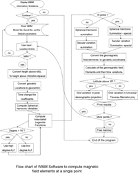
Fig 1. Flow chart of the WMM program to compute magnetic field at a point. Click image for larger version.
|
Geoid implementation in WMM software.
In this implementation of the WMM software, the altitude is referenced to the World Geodetic System 1984
(WGS 84) ellipsoid. This is generally called height above ellipsoid (HAE). However,
WMM users are often more familiar with the height above mean sea level (AMSL). The
difference between AMSL and HAE varies with location and the total variation is less
than 200 meters. The software allows the user to enter their altitude above the mean sea
level rather than their height above ellipsoid. Conversion between heights referenced to
MSL and WGS84 ellipsoid has been implemented using the EGM96 geoid. Figure 2
shows the effect of geoid elevation correction at sea level for the year 2010 in the total
field. The correction results in a difference of magnetic field strength of about 1-3 nT.
The largest differences in magnetic field strength coincide with the largest deviations of
the geoid from the WGS-84 ellipsoid. However, the effect of geoid height correction is
negligible in the magnetic declination. The EGM-96 geoid height file will also be
supplied with the WMM package for this purpose. This option is enabled by default.
|
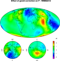
Fig 2. The effect of geoid elevation correction on the total field, F in WMM2010. Click image for larger version.
|
|
|
Use of WMM software for high degree geomagnetic models
The software accurately computes the associated Legendre functions up to degree 2800,
making it adaptable for high-degree geomagnetic models.
Details of the World Magnetic Model derivation are described in The US/UK World Magnetic Model for 2020-2025: Technical Report (available February 2020).
|
|
