
The High Definition Geomagnetic Model (HDGM) is a global, high-resolution model of Earth's geomagnetic main and crustal field. The model provides magnetic field values (total field, dip, and declination) at any point above or below the Earth's surface. The HDGM is updated annually to correctly model secular changes in the geomagnetic field.
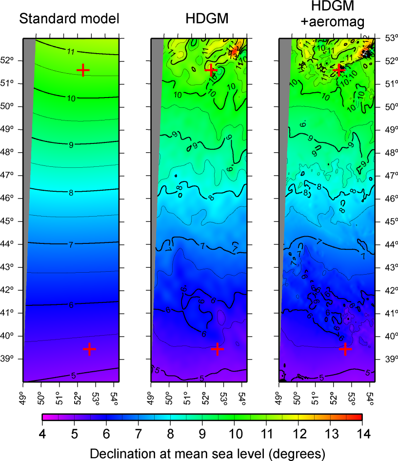
HDGM provides higher resolution magnetic directional (or pointing) information than standard models, as demonstrated by the model comparison figure for the Caspian Sea.
Model Features
- Easy integration with most well planning software
- High resolution crustal field to degree 790 providing accurate down-hole declination and dip values
- Main field and secular variation models spanning years 1900-present
- Average external field model to estimate disturbance field
- Uncertainty estimates using ISCWSA error model
- GUI executable and Excel interface
- GUI provides with easy access to the Earth Magnetic Anomaly Grid (EMAG2v3) map
- C-language library source code included for custom development needs
Recent Updates to HDGM2024
- Incorporated 10 years of data from the Swarm satellite mission
- Main field and secular variation update valid until December 31, 2024
- Updated main field model from 2022 to 2024
- Introduced a Web-API for HDGM
- Continuous update of geomagnetic activity indices used as input to the magnetic diurnal variation mode
Send all support inquiries and price quote requests to: hdgm.support@noaa.gov
NOAA's National Centers for Environmental Information, E/GC 325 Broadway Boulder, Colorado USA 80305-3328

November 8, 2023
- Main field and secular variation update valid until December 31, 2024
- Updated the main field models from 2022 to 2024
- Incorporated 10 years of data from Swarm satellite mission
- A new Web API for HDGM
- Software updates and bug fixes
November 15, 2022
- Main field and secular variation update valid until December 31, 2023
- Updated the main field models from 2021 to 2023
- Incorporated 9 years of data from Swarm satellite mission
- Improved Dst forecasting using MagNet ensemble modeling
- Updated diurnal magnetic variations model (DIFI-7) in HDGM-RT
- Software updates and bug fixes
November 15, 2021
- New, improved coverage map
- Incorporated 8 years of data from the Swarm satellite mission
- Main field and secular variation update valid until December 31, 2022
- Updated main field model from 2020 to 2022
- Updated diurnal magnetic variations model (DIFI-6) in HDGM-RT
November 12, 2020
- New crustal field derived from EMAG2v3 crustal anomaly grid
- Incorporated 7 years of data from the Swarm satellite mission
- Main field and secular variation update valid until December 31, 2021
- Updated main field model from 2014 to 2021 with a combination of Swarm, DMSP, Cryosat, and CHAMP data
November 14, 2019 (HDGM-2020)
- Incorporated 6 years of data from Swarm satellite mission
- Main field and secular variation update valid until December 31, 2020
- Updated HDGM-RT with improved nowcasting of magnetic disturbance field
- Updated main field model from 2002 to 2020 with a combination of Swarm, DMSP, Cryosat, and CHAMP data
November 15, 2018 (HDGM-2019)
- Incorporated almost 5 years of data from the Swarm satellite mission
- Main field and secular variation update valid until December 31, 2019
- Implemented ionospheric DIFI-4 model within the HDGM-RT package
- Easy access to the Earth Magnetic Anomaly Grid (EMAG2v3) map from HDGM GUI software
December 11, 2017 (HDGM-2018)
- Incorporated over 3 years of data from the Swarm satellite mission
- Main field and secular variation update valid until 2019.0
- Implemented ionospheric DIFI-3 model within the HDGM-RT package
- Improved and streamlined documentation
March 6, 2017 (HDGM-2017)
- Incorporated over 3 years of data from the Swarm satellite mission
- Main field and secular variation update valid until 2019.0
- Implemented ionospheric DIFI-2 model within the HDGM-RT package
March 17, 2016 (HDGM-2016)
- Incorporated over 2 years of data from the Swarm satellite mission
- Main field and secular variation update valid until 2018.0
- Implemented HDGM-RT Real-Time Disturbance model as an optional addition to the standard
March 17, 2015 (HDGM-2015)
- Incorporated more than one year of data from the Swarm satellite mission
- Main field and secular variation update valid until 2017.0
- Retroactive updates of models for 2010-2014 using new Swarm data
- Extended main field model back to 1900, so now HDGM covers all time periods 1900-present
- Updated external disturbance field prediction for 2015
May 7, 2014 (HDGM-2014)
- Incorporated data from DMSP satellites for 2010-2014 models
- Main field and secular variation update valid until 2016.0
- Updated external disturbance field prediction for 2014
License Holders
HDGM Real-Time
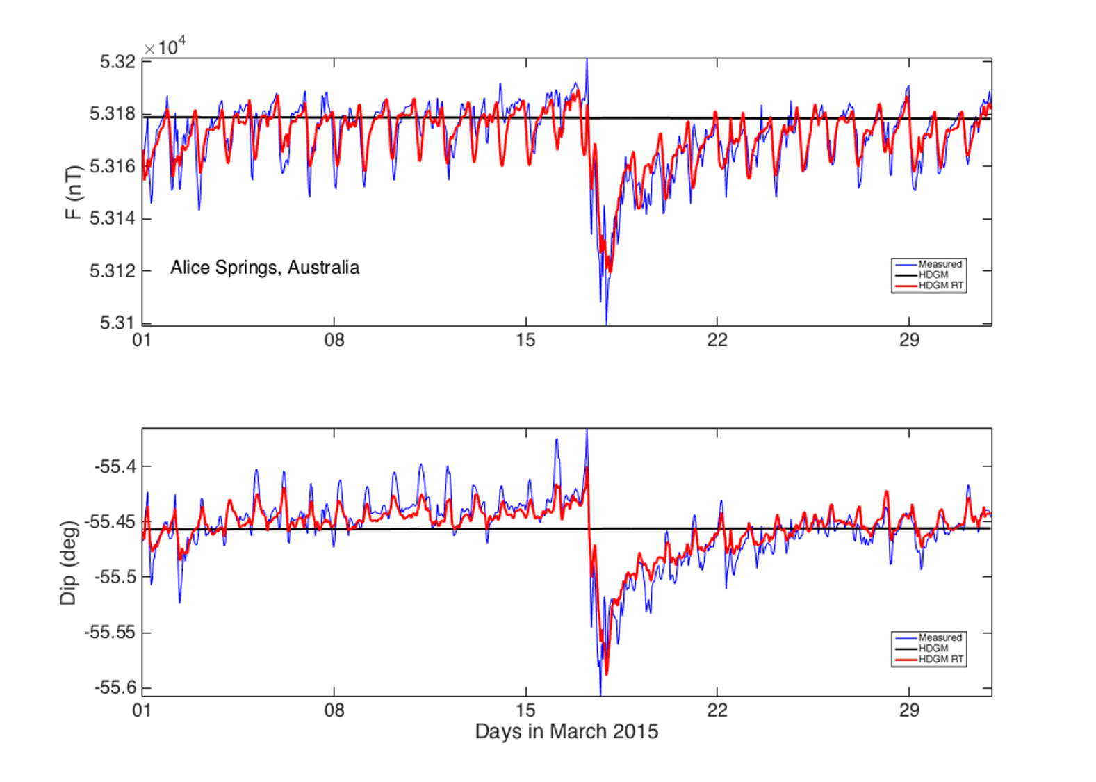
HDGM Real-Time (RT) was developed by NOAA in partnership with the directional drilling industry and the University of Colorado. The RT version improves the base model by accurately modeling the magnetic fields originating in Earth's magnetosphere. It runs on input data from a combination of solar-wind observing satellites situated between Earth and the sun and a chain of geomagnetic observatories on Earth's surface.
The model also includes a climatological model of the magnetic diurnal variation originating in the ionosphere, inferred from a combination of observatory and Swarm satellite data. The addition of HDGM-RT can save rig time and reduce the drilling cost by enabling improved drill string interference correction during adverse space weather conditions.
Limitations: Currently, the disturbance and diurnal fields modeling is limited to the low and mid-latitudes (< |55°|) of the Earth. Additionally, the HDGM-RT output is less accurate than actual measurements of magnetic time variations at a close by observatory. Finally, the real-time modeling may occasionally be affected by data outages from satellites and observatories.
| Compare Model Features | IGRF | HDGM | HDGM-RT |
|---|---|---|---|
| Average secular variation (5-year) | ✔ | ✔ | ✔ |
| Rapid secular variation (1-year) | ✔ | ✔ | |
| 150 km crustal resolution (satellite) | ✔ | ✔ | |
| 25 km crustal resolution (airborne/marine surveys) |
✔ | ✔ | |
| Annually averaged disturbance field | ✔ | ✔ | |
| Real-time disturbance field (magnetosphere) | ✔ | ||
| Diurnal variation (ionosphere) | ✔ |
RT Model Features
- Includes all features of the standard HDGM model
- External field model to estimate disturbance field calculated in real-time*
- Modeling of geomagnetic storm disturbances from 2014 to present
- Improvement in magnetic field prediction during periods of strong solar activity
- Ionospheric daily variations from mid- and low-latitude current systems
- Updated HDGM-RT with improved nowcasting of magnetic disturbance field
*Real-time modeling depends on live data streaming from observatories and satellites. Due to potential data linkage and corruption issues, a delay of real-time value calculations of up to 2 hours is possible. The disturbance field is the magnetospheric magnetic field and diurnal variation (ionospheric field at mid and low latitudes).
HDGM Error Model for Measurement While Drilling (MWD) Operations
The error model is a scaled version of the magnetic error values provided in the Industry Steering Committee on Wellbore Survey Accuracy (ISCWSA) Measurement While Drilling (MWD) model (Reference: SPE 67616). The multiplier was derived by comparing measured Total Magnetic Field Strength values with those predicted by the geomagnetic models. The Declination and Magnetic Dip angular values were checked to confirm the same multiplier was valid. The error values in the following table may be interpreted as one standard deviation difference between a hypothetical measurement and the calculator result for a location. More details of the scaling method are available in the paper SPE 151436.
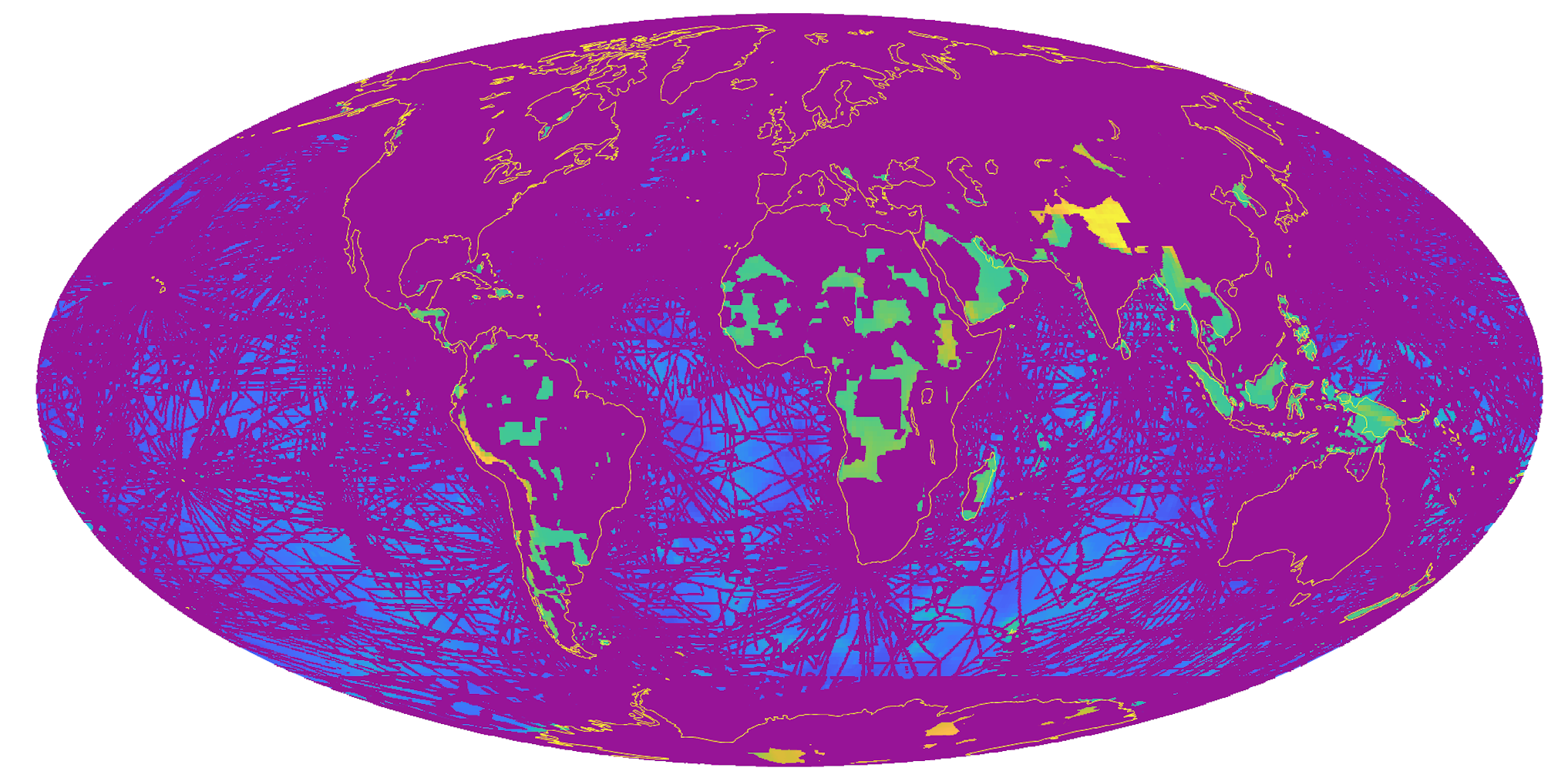
For locations where magnetic survey data are not available, the HDGM software outputs the Standard ISCWSA model error, reflecting the lower resolution of the model at that location. See Figure 1 for HDGM’s magnetic data coverage (purple, see paper OTC-31044-MS).
| Model | Multiplier |
|---|---|
| HDGM | 0.82 |
| Standard | 1.00 |
| IGRF/WMM | 1.21 |
| Model | Total Field | Dip Angle | Azimuth (Constant) | Azimuth (BH Dependent) |
|---|---|---|---|---|
| MFI (nT) | MDI (Deg) | AZ (Deg) | *DBH (Deg.nT) | |
| HDGM | 107 | 0.16 | 0.30 | 4118 |
| Standard | 130 | 0.20 | 0.36 | 5000 |
| IGRF/WMM | 157 | 0.24 | 0.43 | 6029 |
Error Model References
- SPE 67616; Williamson, H. S. (2000). Accuracy prediction for directional measurement while drilling. SPE Drilling & Completion, 15(04), 221-233 https://www.onepetro.org/journal-paper/SPE-67616-PA
- SPE 151436; Maus, S., M. C. Nair, B. Poedjono, S. Okewunmi, J. D. Fairhead, U. Barckhausen, P. R. Milligan, J. Matzka (2012), High Definition Geomagnetic Models: A New Perspective for Improved Wellbore Positioning, IADC/SPE Drilling Conference and Exhibition, 6-8 March 2012, San Diego, California, USA, doi: 10.2118/151436-MS https://www.onepetro.org/conference-paper/SPE-151436-MS
Related Publications
- Nair, M., M. Kruglyakov and A. Kuvshinov, On the Use of Adjacent Land-Based Magnetic Field Data to Correct for Geomagnetic Disturbances During Offshore Directional Drilling, Industry Steering Committee on Wellbore Survey Accuracy (ISCWSA) 57th General meeting, March 10, 2023, Stavanger, Norway. https://www.iscwsa.net/media/files/events-event/0a481da7/01-proper-use-land-mag-obsi-scwsa-57th-manoj-nair-ver3.pdf
- Nair, M. , A. Chulliat, A. Woods, P. Alken, B. Meyer, B. Poedjono, N. Zachman, and J. Hernandez, Next Generation High-Definition Geomagnetic Model for Wellbore Positioning, Incorporating New Crustal Magnetic Data. Paper presented at the Offshore Technology Conference, Virtual and Houston, Texas, August 2021. Paper Number: OTC-31044-MS doi: https://doi.org/10.4043/31044-MS
- Nair, M., P. Alken and A. Chulliat, Forecasting the magnetic disturbance-storm-time (Dst) index using machine-learning. Industry Steering Committee on Wellbore Survey Accuracy (ISCWSA) 48th meeting, September 27, 2018, Dallas, TX https://www.iscwsa.net/media/files/files/d38b39a3/iscwsa-spe-wpts-manoj-nair-2018-sept.pdf
- Chulliat, A., M. Nair, P. Alken, B. Meyer, R. Saltus, A. Woods and B. Poedjono, New Capabilities of NOAA’s High-Resolution Geomagnetic Reference Models. Industry Steering Committee on Wellbore Survey Accuracy (ISCWSA) 46th meeting, October 12, 2017, San Antonio, TX. https://www.iscwsa.net/media/files/files/14e1f5ae/8-iscwsa-spe-wpts-chulliat.pdf
- Nair, M., A. Chulliat, A. Woods, P. Alken, B. Meyer and R. Saltus, New approach to quantify uncertainty for high-resolution magnetic reference models, Industry Steering Committee on Wellbore Survey Accuracy (ISCWSA) 45th meeting, March 17, 2017, The Hague, Netherlands. https://www.iscwsa.net/media/files/files/343888c9/12-jonbang-spe-184644-spe-wpts-icswsa-march-17.pdf
- Alken, P., A. Chulliat, M. Nair, B. Meyer, R. Saltus, A. Woods, N. Boneh, New advances in geomagnetic field modeling, Industry Steering Committee on Wellbore Survey Accuracy (ISCWSA) 44th meeting, September 22nd, 2016, Glasgow, Scotland. https://www.iscwsa.net/media/files/files/d3b30bb0/08-isc44-patrickalken-noaa-geomagmodeling.pdf
- Chulliat, A., P. Vigneron, G. Hulot, First result from the Swarm Dedicated Ionospheric Field Inversion chain, Earth Planets and Space, 68, 2016, doi: 10.1186/s40623-016-0481-6.
- Chulliat, A., P. Vigneron, E. Thebault, O. Sirol, G. Hulot, Swarm SCARF Dedicated Ionospheric Field Inversion chain, Earth Planets Space, 65, 1271-1283, 2013. http://geomag.colorado.edu/images/DIFI2015/chulliat_etal_EPS_2013.pdf
- Nair, M., A. Woods, A. Chulliat, P. Alken and N. Boneh, A real-time magnetic disturbance model to improve drilling accuracy in low and mid latitudes of the Earth, Industry Steering Committee on Wellbore Survey Accuracy (ISCWSA) 42nd meeting, October 1, 2015, Houston, Texas USA. https://www.iscwsa.net/media/files/files/73a6da7c/06-isc42-real-time-magnetic-disturbance.pdf
-
Maus, S., Nair, M., Woods, A., Gannon, J. L., Finn, C. A. & Love, J. J., The NGDC/USGS real-time magnetospheric disturbance field calculator, Industry Steering Committee on Wellbore Survey Accuracy (ISCWSA) October 11, 2012, San Antonio, Texas USA. https://www.iscwsa.net/media/files/files/7d638a33/meeting-36-ngdc-usgs-real-time-magnetospheric-disturbance-field-calculator.pdf
Disclaimer of Liability
While the National Environmental Satellite Data and Information Service (NESDIS) makes every effort to ensure that its databases are error-free, errors do occur. We ask that you notify us immediately of any errors that you discover in our data. We will make every effort to correct them.
With respect to documents available from this server, neither the United States Government nor any of its employees, contractors, or affiliates make any warranty, express or implied, including the warranties of merchantability and fitness for a particular purpose; nor assumes any legal liability or responsibility for the accuracy, completeness, or usefulness of any information, apparatus, product, or process disclosed; nor represents that its use would not infringe privately owned rights.
Disclaimer of Endorsement
Reference to any specific commercial products, process, or service by trade name, trademark, manufacturer, or otherwise, does not constitute or imply its endorsement, recommendation, or favoring by the United States Government. The views and opinions of authors expressed on NESDIS websites do not necessarily state or reflect those of the United States Government, and shall not be used for advertising or product endorsement purposes.


