|
World Data Service for Geophysics
Total Sediment Thickness of the World's Oceans and Marginal Seas
Version 3 (GlobSed)
Download Data
See also: Version 2; Version
1
How to cite:
Straume, E.O., Gaina, C., Medvedev, S., Hochmuth, K., Gohl, K., Whittaker, J. M., et al. (2019). GlobSed: Updated total sediment thickness in the world's oceans. Geochemistry, Geophysics, Geosystems, 20.
DOI: 10.1029/2018GC008115
Summary:
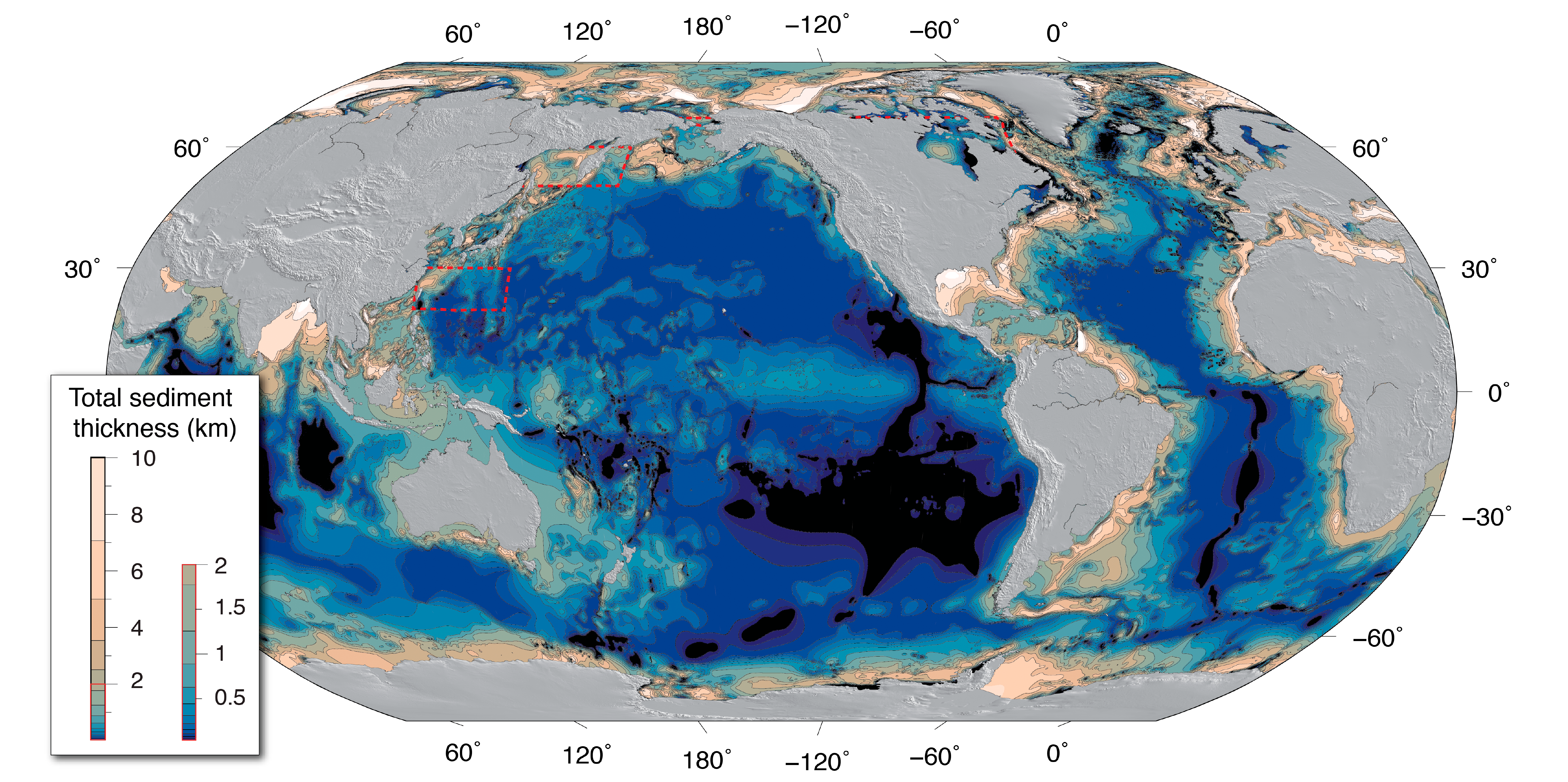
NCEI's global ocean sediment thickness grid of Divins (2003) updated by
Whittaker et al. (2013) has been updated again for the NE Atlantic, Arctic, Southern Ocean, and
Mediterranean regions.
The new global 5‐arc‐minute total sediment thickness grid, GlobSed, incorporates new data and several regional oceanic sediment thickness maps, which have been compiled and published for the, (1) NE Atlantic (Funck et al., 2017; Hopper et al., 2014), (2) Mediterranean (Molinari & Morelli, 2011), (3) Arctic (Petrov et al., 2016), (4) Weddell Sea (Huang et al., 2014), and (5) the Ross Sea, Amundsen Sea, and Bellingshausen Sea sectors off West Antarctica (Lindeque et al., 2016; Wobbe et al., 2014). This version also includes updates in the White Sea region based on the VSEGEI map of Orlov and Fedorov (2001).
GlobSed covers a larger area than NCEI’s previous global grids (Divins, 2003; Whittaker et al. 2013), and the new updates results in a 29.7% increase in estimated total oceanic sediment volume.
References:
Divins, D. (2003). Total sediment thickness of the world's oceans and marginal seas. Boulder, CO: NOAA National Geophysical Data Center.
Funck, T., Geissler, W. H., Kimbell, G. S., Gradmann, S., Erlendsson, Ö., McDermott, K., &
Petersen, U. K. (2017). Moho and basement depth in the NE Atlantic Ocean based on seismic refraction data and receiver functions. Geological Society, London, Special Publications, 447(1), 207–231.
doi: 10.1144/SP447.1
Hopper, J. R., Funck, T., Stoker, T., Arting, U., Peron‐Pinvidic, G., Doornenbal, J. C., & Gaina, C. (2014). Tectonostratigraphic atlas of the north‐east Atlantic region. 340 pp., GEUS, Copenhagen, Denmark.
Huang, X., Gohl, K., & Jokat, W. (2014). Variability in Cenozoic sedimentation and paleo‐water depths of the Weddell Sea basin related to pre‐glacial and glacial conditions of Antarctica. Global and Planetary Change, 118, 25–41.
doi: 10.1016/j.gloplacha.2014.03.010
Lindeque, A., Gohl, K., Wobbe, F., & Uenzelmann‐Neben, G. (2016). Preglacial to glacial sediment thickness grids for the Southern Pacific Margin of West Antarctica. Geochemistry, Geophysics, Geosystems, 17, 4276–4285.
doi: 10.1002/2016GC006401
Molinari, I., & Morelli, A. (2011). EPcrust: A reference crustal model for the European Plate. Geophysical Journal International, 185(1), 352–364.
doi: 10.1111/j.1365-246X.2011.04940.x
Petrov, O., Morozov, A., Shokalsky, S., Kashubin, S., Artemieva, I. M., Sobolev, N., et al. (2016). Crustal structure and tectonic model of the Arctic region. Earth‐Science Reviews, 154, 29–71.
doi: 10.1016/j.earscirev.2015.11.013
Whittaker, J. M., Goncharov, A., Williams, S. E., Müller, R. D., & Leitchenkov, G. (2013). Global sediment thickness data set updated for the Australian‐Antarctic Southern Ocean. Geochemistry, Geophysics, Geosystems, 14, 3297–3305.
doi: 10.1002/ggge.20181
Wobbe, F., Lindeque, A., & Gohl, K. (2014). Anomalous South Pacific lithosphere dynamics derived from new total sediment thickness estimates off the West Antarctic margin. Global and Planetary Change, 123, 139–149.
doi: 10.1016/j.gloplacha.2014.09.006
Orlov, V. P. and Fedorov, D. L. (2001). Hypsometric Map of the Crystalline Basement Surface in the Central and Northern East European Platform on a Scale 1: 2500000. (VSEGEI, St. Petersburg, 2001) [in Russian].
Version 2 (2013)
Download Data
ISO Metadata
How to Cite Version 2 Data:
Whittaker, Joanne, Alexey Goncharov, Simon Williams, R. Dietmar Müller, German Leitchenkov (2013) Global sediment thickness dataset updated for the Australian-Antarctic Southern Ocean, Geochemistry, Geophysics, Geosystems.
doi: 10.1002/ggge.20181
Summary
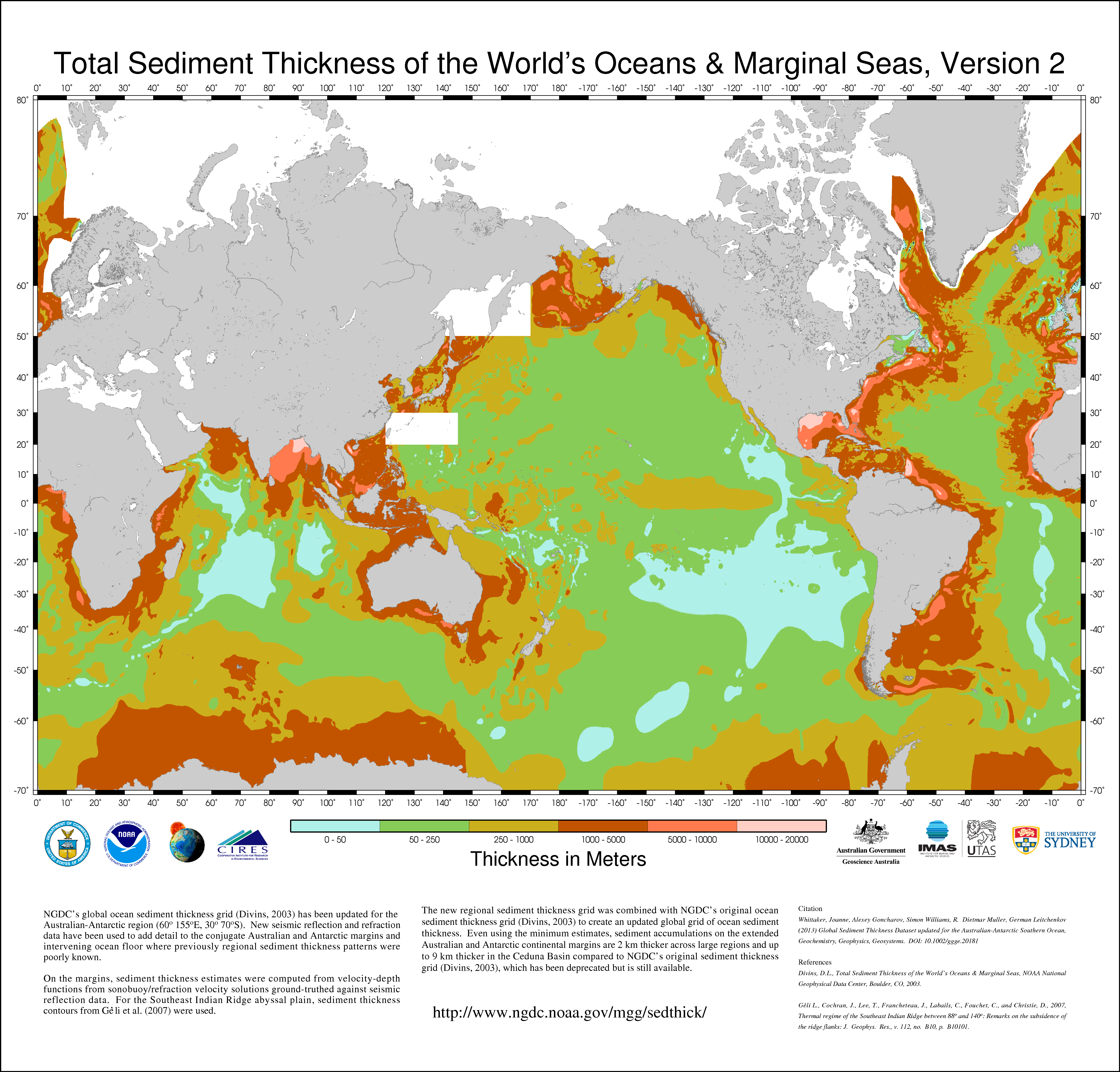
NCEI's global ocean sediment thickness grid (Divins, 2003) has been updated for the Australian-Antarctic region (60°-155°E, 30°-70°S). Seismic reflection and refraction data have been used to add detail to the conjugate Australian and Antarctic margins and intervening ocean floor where previously regional sediment thickness patterns were poorly known.
On the margins, sediment thickness estimates were computed from velocity-depth functions from sonobuoy/refraction velocity solutions ground-truthed against seismic reflection data. For the Southeast Indian Ridge abyssal plain, sediment thickness contours from Géli et al. (2007) were used.
The regional sediment thickness grid was combined with NCEI's original ocean sediment thickness grid (Divins, 2003) to create an updated global grid of ocean sediment thickness. Even using the minimum estimates, sediment accumulations on the extended Australian and Antarctic continental margins are 2 km thicker across large regions and up to 9 km thicker in the Ceduna Basin compared to NCEI's original sediment thickness grid (Divins, 2003), which has been deprecated but is still available.
References:
Divins, D.L., Total Sediment Thickness of the World's Oceans & Marginal Seas, NOAA National Geophysical Data Center, Boulder, CO, 2003.
Géli, L., Cochran, J., Lee, T., Francheteau, J., Labails, C., Fouchet, C., and Christie, D., 2007, Thermal regime of the Southeast Indian Ridge between 88°E and 140°E: Remarks on the subsidence of the ridge flanks: J. Geophys. Res., v. 112, no. B10, p. B10101.
Version 1 (2003)
See:
Total Sediment Thickness of the World's Oceans and Marginal Seas, (Divins, 2003)
|
|