Data Types:
- Bathymetry (Single Beam)
- Gravity
- Magnetics (including Airborne)
- Seismic Reflection
(Multi- & Single Channel)
- Seismic Refraction
- Shot-Point Navigation
- Side Scan Sonar
- Subbottom Profile
Also see:
|
|
World Data Service for Geophysics
Marine Trackline Geophysical Data
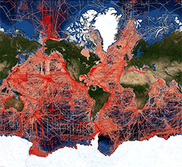
NCEI's Marine Trackline Geophysical database provides bathymetry (single-beam), magnetics, gravity and seismic reflection data collected during marine cruises from 1939 to the present. Data sources include US and non-US oceanographic institutions, universities, and government agencies with worldwide data coverage.
Locating and Downloading Data
Data are available via the
Trackline Geophysical Data Viewer. Search by geographic area, year of survey, institution, platform, survey name, date added to the database, and data type are available. Downloads can be customized to area, data type, and format.
Data can be exported in the
MGD77T Exchange Format, which contains a documentation header record and data records. Header records provide metadata for each survey. Data records contain geophysical data (bathymetry, magnetics, gravity, and seismic shot-point IDs) with time and position. MAG88T Exchange Format is used for airborne magnetic surveys, aeromagnetics, for reporting scalar or vector magnetic observations.
Ancillary, analog and high-volume geophysical data, including seismic reflection and refraction, side-scan sonar, are available. Analog data are also provided as scanned image files.
Contributing Data
NCEI accepts contributions of underway geophysical data on almost any media, preferably in the
MGD77T Format. Data received become part of the international public domain, available to anyone. Proprietary data can also be archived at NCEI. If you would like to contribute data, contact
GEODAS-NG Desktop Software
NCEI's GEODAS-NG (GEOphysical DAta System - Next Generation) desktop software is used to work with trackline data formats.
Download GEODAS-NG Software Ver 1.1.3 (installation instructions)
While this software suite is expected to work for some time, support for updates may not be available after 2014.
It may be useful to explore other tools to determine if they meet your needs.
GEODAS-NG Software and non-NCEI sites use data exchange formats (MGD-2000) developed at
NCEI:
Contour Data Shapefiles:
GEODAS-NG Software application Hydro-Plot can be used to view contoured data in ESRI shapefile format. NCEI provides contours via various types of data, including Great Lakes Bathymetry.
GEODAS-NG Desktop Windows Software:
software can be used for NCEI data, however it does not support the legacy GEODAS CD and
DVD datasets.
Legacy GEODAS CD/DVD users: Update to GEODAS DVD Software Update Ver 5.0.24.6. GEODAS DVD Software co-exists with the latest GEODAS-NG Software.
|

